- CCT Public Page
- [CCT Members Area]
Blog from July, 2010
Just like to inform you all that i did the climbing community a favor during the last few days.
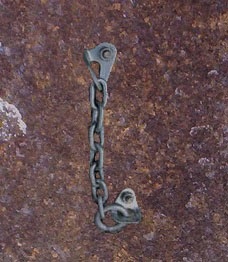
I managed to install rap anchors on the Ben Lomond massif in 3 locations to "in my humble and unbiased opinion provide a better experience" I have painted them also so might be hard to find at first.
The rap stations are Fixe Rap Anchor's and have all been classified as "IMMORTAL" These anchor's "will endure for as long as the sport of climbing lasts."
Fixe anchor on face of robins buttress
57 holds plus 2.1m wooden panels from woody for sale. Best offer. Ph 0428505259
I'm after a pair of chains for my 4WD, preferably something that is fairly heavy duty and won't disintegrate when they are needed.
Tyre size is 265/70/R16
If you've got a pair stashed away and want to get rid of them, let me know. emjones at internode dot on dot net
Cheers
EJ
1 pair of yellow Rock Pillar climbing shoes size US 9 found hanging on a tree at Hillwood. If they are yours they are now at MD's Launceston awaiting collection, ph 63340988. If not collected they will be available for use on the bouldering wall for passing climbers!!!
I pulled a cam out of Nefertiti on Mt Wellington. Is it yours? Contact me on 0403 217754 if you want it back!
It looks a little twisted and ugly now, but not too bad - it works anyway! Yeah if it looked really good... I probably wouldn't have posted this message!! :)
Given so much exploring and rediscovering of cliffs goes on in tassie, i thought I might start posting some of the cliffs I've checked out over time - might prevent some effort rediscovering them. I'd encourage other people to do the same - then I wont have to rediscover your choss pile.
Today I went out and checked out some cliffs at the end of Glen Dhu Rd. To get there drive towards New Norfolk, and turn left at Sorell Creek. Take a right on Glen Dhu Rd and follow it along way up the valley. Just before you come to a gate with a private property sign a road heads down right to the creek - park here. If you come to a shipping container youve gone too far. From the road you can see the cliffs up the hill to the right. There are 2 more substantial cliff lines further up the valley (see pics). The cliffs are marked on the 1:25k map with the imagantive name "Yellow Cliffs". The cliff is on public land but there is private land around in the valley.
Link to theList map:
http://www.thelist.tas.gov.au/listmap/listmap.jsp?llx=507375.79129570146&lly=5255517.566708777&urx=510988.36091397353&ury=5256985.0664639585&layers=17&disabledlayers=
The track on this google map shows the 4wd tracks from the car to where you head up the hill:
http://maps.google.com/maps?f=q&source=s_q&hl=en&geocode=&q=http:%2F%2Fwww.thesarvo.com%2Fconfluence%2Fdownload%2Fattachments%2F170917890%2FTrack%2B009.kmz&sll=-42.84759,147.10968&sspn=0.028129,0.077162&ie=UTF8&t=h&z=15
From the park follow the road down to the creek, and then up the right hand side of the creek for about 10 minutes. This leads to under the cliffs. Then its a steep strenous walk up the hill to the cliffs - about 40 mins total to reach the base of the cliff. The bush is generally open but its a big walk up. We walked up the ridge leading to the big roof - but you are better off going along further and walking up the second ridge to the left of the big gully that comes down from the middle of the cliff - as the good rock is on the LH side.
The cliff is 30-40m high sandstone and a typical mixture of total choss and some good bits. In all its similar to Handsomes and Nieka, but harder access than either. Not too much lichen but quite dirty in places. There would definitely be some good sport routes here but I'm guessing the walk is a bit too much effort. You would need to be motivated.
If access from the top was somehow possible (Ringwood Fire Trail??) then maybe, but I don't reckon I will go back. There is probably a bit more rock to explore in the general area.
Photos below. To see the high res versions go to http://www.thesarvo.com/confluence/pages/viewpageattachments.action?pageId=170917890
|
|
|
|
|
|
A good buttress of quite good looking rock
|
Middle of the cliff
|
Middle of the cliff
|
Roof sorta solid
|
|
|
|
|
|
|
Classic looking off width thru the roof
|
Nice wall
|
More big rooves and choss
|
Black rock is solid but a bit dirty
|
|
|
|
|
|
|
Big roof on RH end
|
More cliffs further up the valley
|
The big roof - chossy
|
The cliffline
|
|
|
|
|
|
|
Nice sized boulder on good rock - pity its blank
|
More cliffs further up the valley
|
Better rock
|
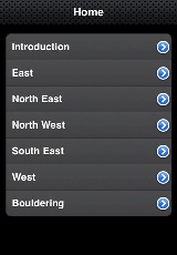
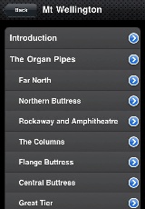
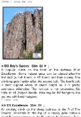
I'm pleased to announce that the thesarvo iPhone app is now in the app store.
Version 1.0 gives offline access in a mobile optimised interface to all of the Tasmanian route and boulder guides on thesarvo - over 3000 routes and 1500 problems.
It's priced at a reasonable $3.99 - proceeds go to the running of this site.
Installing it
To install it search for "thesarvo" on the iPhone app store, or go here:
http://itunes.apple.com/us/app/thesarvo/id379419619?mt=8
You need to be on Wi-Fi to install it as the app is about 60mb with all the topos included.
It should also work on an iPod Touch (although I havent tested it).
Bugs and Feature Requests
Version 1.0 is pretty basic, and there are a lot more features that could be added over time - I'm interested to hear what you think would be useful in the next version. Probably the biggest ones on my list are:
- GPS/maps integration
- Favourites and comments
- Automatic updates - at the moment updates will be through the app store
- Remember which climb you are looking at when the app is closed
Also please post any bugs or issues you find here and I will try and fix them in the next version.
Screenshots
|
|
|
|
|
iPhone app screenshot 1
|
iPhone app screenshot 2
|
iPhone app screenshot 3
|
iPhone app screenshot 4
|
Hey Guys!!
I'm looking for some information on fruehauf and some photos when it was first started,
does any one know where i can get it???
Hi All,
I'm staying in Hobart at the moment and have plenty of free time to climb. Unfortunately most people I know here work way too much during the week, so if anyone is keen for weekday climbing (or surfing!) missions then let me know. Happy to boulder, sport, trad, whatever.
JC
email jonathonclearwater (at) gmail.com or txt me on +64 210604090
Hey John, Awesome resource for climbing in Tassie!! Noticed there is no online Hillwood guide ... whats the chance of getting one up and running? Ive got some good photos after a recent trip that could be used for topos.
Cheers
Guy
