
Schouten Island
 Up to 45 min
 Mixed sun
 Coastal Granite
Acknowledgement
Norm Selby and Nick Hancock.
Introduction
There have been several expeditions to climb on the granite at Schouten Island, off the south coast of Freycinet Peninsula.
Access
To get there you'll need a boat of some description. Head through Schouten Passage and into Trumpeter Bay. At the back of the bay is a penguin colony and small creek. Head ashore here. This is probably also the best spot to camp, as it is one of few with water. Shootin' Dome (as the first cliff is called) is a 50m high inland dome, head SSW through the bush behind camp for about 2km (follow the most obvious weakness as there's no track). The dome is on a high point and should be pretty obvious after about 30 mins. There is no real track up to the cliff, but approximately 45 minutes of bush bashing should get you there. Head for the slabs, which will then lead up to the Dome. Descent is best facilitated by walking down either left or right (depending on which is closest to your gear), though the FA party left a bomber wire in a central spot and used this while they were there to make descending easier. For the most part the climbing is on natural gear, but there are a few rap-placed carrots to ease the tension, so don't forget a couple of brackets.
GPS
Shootin Dome
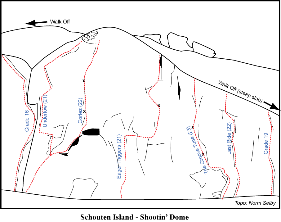
Up the widish crack on the left of the dome (left of main arete), to a roof. Pass this and follow the left trending line to the top.
Robert Mcmahon, Adam Donoghue, Norm Selby, 1998.
Start on the left hand arête of the main face. Head up for approx. 10m following the beautiful smooth hand crack, until it is possible to traverse left to the arête. Follow this until it is possible to follow the line and gear back rightwards to the top. A little spaced with gear but not frightingly so, a great all natural route on superb rock. The best route on the dome and a real stand out pitch.
Adam Donoghue, Norm Selby, Robert McMahon, 1998.
Start as for Under Tow, but head right after 10m to the orange stripes and crack. A strong line and a little reminiscent of the climb 'Incipience'. A testing lead with sustained slabbing though very rewarding and a high quality climb. Up obvious cracks then a carrot to get to next crack system, then out onto crux slab with two more bolts and some exposure.
Adam Donoghue, Norm Selby, Robert McMahon, 1998.
Start 5m right of Cortez the Killer. Climb the crack for around 10m, at which point you can move right a few meters and up to a carrot. From the bolt make your way left to the weakness and then back right to the top. A great climb that wanders in a interesting path up a good section of the dome.
Adam Donoghue, Norm Selby, Robert McMahon, 1998.
Start 10m right of Eager Triggers, on the right of a leaning block at the obvious tube feature. Climb the block and the water washed groove, passing two carrots and some gear on the way. Quite thin slabbing to get going before easing to an interesting face/slab climb.
Adam Donoghue, Norm Selby, Robert McMahon, 1998.
Climb the incipient crack line a few meters right of Groove Tube. Quite runout and unlikely. Norm retreated upwards on the first ascent with the runout and difficulties escalating he gurgled down "I think I'm going to puke!" Character building, not for someone with a weak stomach!
Norm Selby, Adam Donoghue, Robert McMahon, 1998.
A few meters right of the last climb is the easiest line on the main face.
Adam Donoghue, Norm Selby, Robert McMahon, 1998.
About 15 to 20 meters right of the last climb is a wandering thin crack that leads up the slab. Follow this to the top.
Robert McMahon, Adam Donoghue, Norm Selby, 1998.
To find this climb wander around to the back of the cliff to find a obvious crack-line near a boulder behind a tree. Climb to the top of the boulder and gain the left trending diagonal. Follow this, via the off-width, to the top. Was pretty weepy on the first ascent (a wet version of Incipience!).
Robert McMahon, Adam Donoghue, Norm Selby, 1998.
Sennen Point
Compared to much of the local sea cliff, this area is very friendly, being only 25 metres high and only 250 east of the entrance to Trumpeter Bay. It is easily identified by being directly opposite a rock 3 metres high, 150 metres offshore (shown on the 1:25000 map). Access so far was by dingy from Trumpeter Bay to a sheltered spot just west where it was easy to drag the boat up on the rocks. It should be possible to walk from the campsite at Trumpeter Bay in half an hour. There are ledges leading below most of the cliff and a convenient abseil block (GPS Aus Geo 66, 0608494 5313279) at the western end of the area developed so far.
About 100 metres east of the abseil and starting from higher ledges climb an amazingly juggy overhanging groove, just left of a big corner, to a harder section past a bolt.
Nick & Heather Hancock, Edi Albert & Vonner Keller-Albert, Mar 2010.
Climb over a roof and follow the shallow right facing corner in the long slabby wall to the right of the corner.
Edi Albert & Vonner Keller Albert, Mar 2010.
Follow a line of five bolts up the blank looking slab, via great moves, with a medium cam at the start and finish.
Nick & Heather Hancock, Edi Albert & Vonner Keller-Albert, Mar 2010.
Climb the sharp crack on the right side of a square protruding buttress, starting from a higher ledge, about 50 metres left of the abseil.
Nick & Heather Hancock, Mar 2010.
Around to the right is the last climb easily approached by traversing ledges leftwards from the main abseil. Climb a bulge and acrack in the face above.
Heather & Nick Hancock, Mar 2010.
Climb the cool looking flake, about 10 metres left of, and easily visible from the abseil block, and the slopey but well protected bulge above.
Nick & Heather Hancock, Edi Albert & Vonner Keller-Albert, Mar 2010.
Just right of the offwidth where the previous climb gets going, climb up a good crack.
Vonner Keller-Albert & Edi Albert, Mar 2010 .
Climbs the thin crack right of the easy crack just left of the abseil.
Edi Albert & Vonner Keller-Albert, Mar 2010 .
About 200 metres back towards Trumpeter Bay and further up away from the ocean is a proud buttress with a big hole in it. Chimney up under the hanging flake and come out through the hole, then climb up past more bolts to the top.
Nick & Heather Hancock, Edi Albert & Vonner Keller-Albert, Mar 2010.
Square Face
400 metres north of the entrance to Trumpeter Bay is a small, square, north facing buttress with a sharp right hand arête (GPS Aus Geo 66, 0608233 5314122), again reached by dingy.
Climb the continuous crack just left of the main blankish face.
Edi Albert & Vonner Keller-Albert, Mar 2010.
Climb the flake crack on surprisingly good gear.
Nick & Heather Hancock, Mar 2010.
Climb the tricky slab via 5 bolts and smallish cams.
Edi Albert & Vonner Keller-Albert, Nick & Heather Hancock, Mar 2010.
Climbs the tenuous sharp arête via a small wire, four bolts and some biggish cams.
Nick & Heather Hancock, Edi Albert & Vonner Keller-Albert, Mar 2010.
Masons Downfall
About 200m south of the prow of the Downfall (GR 084151), climb twin cracks in a rust coloured wall, to a step right at a dogleg letterbox in the right crack, and finish up a wider section to belay on a big sloping ledge. Abseil off a good wire or three.
Nick & Heather Hancock, Edi Albert & Vonner Keller-Albert, Mar 2010.
Taillefer Rocks
The Taillefer Rocks are are three small, rugged, granite islands south of Schouten Island. Access by boat to belay on small ledge on north facing cliffs.
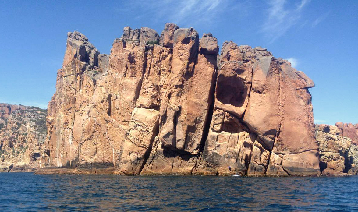
Up easy ramps to mantle to wide crack, up this. Cams from .5 to 4.
Descend via fixed tat on east side of ledge.
Alex Hartshorne & Rosie Hohnen, 2016
Scramble across to belay from easy ledges of no.24. Up wide crack onto awesome headwall finger crack, up this until it ends, arrange gear and run it out up slightly crumbly slab.
Descend via fixed tat on east side of ledge.
Alex Hartshorne & Rosie Hohnen, 2016