
Other Southern Crags
This section contains information about other crags in the South and West of Tasmania for which we do not have full guides for.
Broadmarsh
There is a very small dolerite crag called Fool's Paradise across the river at Broadmarsh - you can see it from the road. Pretty damn worthless, but there were about 10 routes done here in the seventies.
Chauncy Vale
Chauncy Vale (otherwise known as Chossy Vale) is a sandstone valley near Bagdad, about 30 minutes north of Hobart. The road to the start of the walk is sign posted from the main road in Bagdad. Climbing is currently banned, however a couple of bolted routes were put up in the late 90s. To find them, head up walking track that goes up the hill, after about 10 minutes it passes under the first buttress. There is a big roof crack at about 22, then a nice route with about 5 bolts at grade 20. Further right is a good bolted arete. More cliffs were explored and cleaned, but the vast majority of cliffs in the valley are total choss. On the other side of the highway is Green Valley. There are some sandstone cliffs up there that could have potential, but I don't know if they've been climbed on. They are on private land.
Derbyshire Rocks
Derbyshire Rocks is the outrageous choss by the side of the road between New Norfolk and Boyer, on the eastern side of the river. For some unknown reason Phil Robinson "endured" 2 routes there in 1976, documented in CCT circular no 100. Apparently though the smaller outcrop by the side of the river (on the other side) has some deep water soloing.
Kingston - Alum Cliffs
Some routes have been done on the mudstone cliffs north of Kingston Beach. No details are known.
Glendevie
This sandstone crag about an hour south of Hobart has been given a cursory look over by passing climbers over the years but only one climb has been recorded to date. It has some average looking sandstone and is only really worthwhile for locals. From Glendevie, south of Geeveston on the Huon Highway, continue towards Dover for about a kilometre and the crag with a number of detached boulders is visible on the R as the road starts to climb up the hill (GR 991 113, Tasmap 1:25000, Waterloo). In the same area of the world there are a bunch of sandstone buttresses on the south side of the river at Huonville - but they are very chossy.
Gypsy Folk
30m14The route traverses under the huge roof at the RH end of the crags. Disappointingly easy. Start at the obvious crack which runs up to the roof. A hard chimney move, then traverse R to large ledge.
D. Bowman, M. Steane, 26 Nov 1976.
Goats Bluff
Goats Bluff is a sedementary headland passed on the way to South Arm, at the end of Calverts Beach. Park at the Storm Bay carpark lookout.
Too Loose for Lizards
13Rap into the zawn. The climb is the obvious line with 3 bolts and 2 pegs. Clip the bolts with wires (?). Up left to friend placement then down and up to top.
D. Humphries, B. Sellers, Apr 1986.
Longley Edge
These couple of routes were done at Longley Edge in the seventies and are here for historical interest. These days there are houses right up to the cliff which makes things a little awkward.
Osiba
22m16Starts about 15m left of Moongoose at a small crack line on the wall going up to a large tree near the top. 1. 15m Go up to a small overhand and move round this on its left and go up the crack until a move leftwards enables the tree to be reached. 2. 7m Continue up the line on horrifying rock to a belay at the top.
B. Bull, I. Lewis, Oct 1972.
Mongoose
30m17A spectacular pitch. Head across the paddocks to the cliff. At the left end is an eroded cave. 15m to the R is a leftwards slanting crack with three overhangs. 1. 20m (crux). Climb the crack. The crux is a layback move round the central overhang, although the final section may grip some. A large runner needed before the final roof which is laybacked on good undercuts with small footholds to a delicately rotten exit. From the sandy cave move right up the rib for 5m to a bushy ledge and poor belay. 2. 10m Up on rounded holds to finish.
P. Jackson, R. McMahon, Oct 1970.
Ratsack
35m16The corner right of Moongoose. 1. 20m Up the corner to the small overhang. Step R (crux) and mantelshelf. Continue slightly left on poor rock to a poorer finish onto the ledge. 2. 15m Traverse the slab to the left and make an awkward move up into a narrow chimney. Continue up the corner (crux) to an easier finish.
R. McMahon, P. Jackson, J. Moore, Oct 1970.
Mt Hobbs
Mt Hobbs is a dolerite peak near Woodsdale, out the back of Buckland. Some obscure routes were done on it in the 70s.
GPS
Buckleys Chance
★★25m249ÞOn the largest buttress about 50 metres above the road and visible from it, climb the black water streak just right of the main arete. Awesome moves on blank looking rock lead to a final breather just over the small roof. Continue up the easier final wall to a thin finish.
Nick & Heather Hancock, Mar 2014.
Nicholls Rivulet
There is a small sandstone crag about 8km along the Nicholls Rivulet Rd (C626), on the left as you are going south. It was toproped in the 80s and on private land.
Pelverata Falls
There are some small dolerite cliffs along the escarpment that forms Pelverata Falls. Some of these have been toproped and led. There is a very nice bridging corner, about grade 23. With a decent 4WD (or mountain bike) you can drive right to the top of the cliffs via the Snug Tiers. Otherwise you can walk to the bottom via the walking track that starts near the township of Pelverata. Either way, this cliff is of dubious value.
Richmond
 20 minutes
 East Facing
 Sandstone
Acknowledgement
Peter Jackson and Al Adams
Introduction
There are two cliffs at Richmond, located near one another a few kms south of the town. From Bridge St, turn down Henry Street which becomes Commercial Rd. Follow this for 2.4km.
Barwicks Rocks is the obvious cliff situated below the overhead pylon about 500m from the road. Research is required to determine the history and route information for Barwicks Rocks.
The Spice Cliffs are a less conspicuous crag located a further 600m along the road. The crag is 400m from the road across farmland. The rock is sandstone, and on private land.
History
Here’s an extract from the CCT circular penned by Peter Jackson and accompanied by one of his signature sketches.
During 1969 the Spice Cliffs were discovered by McHugh, McMahon and myself. Lots of routes were top-roped but we soon felt the need to establish climbs by leading them.
John Moore led the second ascent of Mace finding it hard. The Victorian Climbing Club visitor, Peter McKeand, felt his way up Herb while we filmed his embarrassed efforts.
By 1971 the little cave route was top roped along with "Time." On the latter, however, vital flakes in the corner came away and the route became “impossible". After this time people moved away and a quiet period followed.
On a nostalgic return visit with John Moore and his new girlfriend, I led the old problem of Sage. That was somewhere in the mid-seventies. Later on a singular visit with Rob McMahon, I once again top roped the central route but we both found there was still no "Time."
1980: Too long has passed. Friends have arrived, and on taking a star pupil Gary Branch to the Spice Cliffs, he leads the little cave route with ease. Herb, Mace and Sage are all led with some super photos emerging from the latter. At the end of the day there is still "Time.” A close inspection reveals a high hidden finger hold which can be used to pull up the overhanging corner to reach the jams in the roof. A couple of sensational layback moves and we are on "Time" again.
Although this cliff is small, the rock architecture has some distinction and the climbs are all different in character and technical interest. Mace has for some time been a minor classic with its well protected crux coming right at the finish. The new "Catnip" is quite a bold climb even with a #3 Friend in the niche. It’s got surprising presence for its size - a great little route.
Belays on the top are difficult and an extra rope is helpful. Traditionally it was customary to gain permission to climb from the farmer, Mr Larry Lazenby, but this year there seems to be no one there.
The scenery is very beautiful despite the drought and if you have not been before it is a good place for a quiet day. The main routes are very photogenic.
The other two cliffs shown on the diagram each contain three steep top rope routes. A couple are very hard, but protection is sparse and the rock rather poor. Nevertheless they can be good fun to extend a session at the Spice Cliffs.
From an article written by Peter Jackson and published in the Climbers Club of Tasmania (CCT) circular in the early 1980s.
Barwicks Rocks
Barwicks Rocks was first developed by John Moore in the late 1960s/early 1970s. No details are currently available on routes at Barwicks Rocks, though the CCT circulars published during this period might contain further information. The crag reputedly is little more than a loose pile of choss.
Spice Cliffs
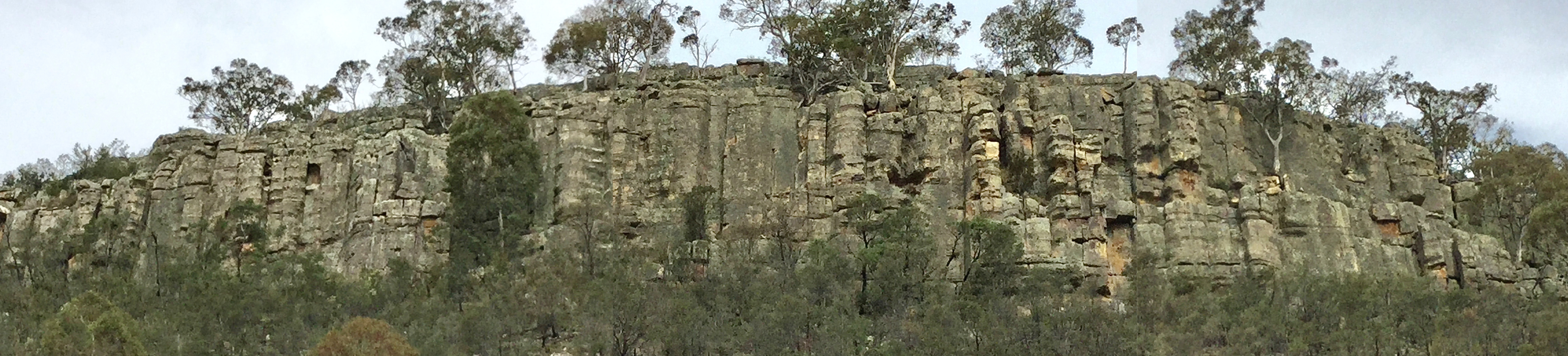
This crag consists of three small buttresses close together that are visible from the road. The crag is on private land. Permission to access the crag needs to be re-established with the landowner. Last known climbing here was in the mid-1980s.
GPS
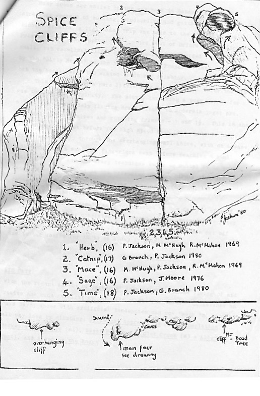
Located on the taller overhanging buttress to the left of the main face. At the left hand end of the buttress is a niche capped by a roof 3m off the ground. Climb around this to the right and onto a small ledge directly below a finger crack through a bulge. Up over the bulge and into a fused corner. Finish up a lichenous slab to a precariously positioned belay tree.
A. Adams, N. Ward and D. Bruce, 30 Sept 1984
The next five routes are all located on the main face. Herb takes the line at the cave at the left hand end,
P. Jackson, M. McHugh and R. McMahon, 1969.
Shared start with Mace, Sage and Time. Takes the left hand finish,
G. Branch and P. Jackson, 1980.
A minor classic. Start as for Catnip. Takes the direct finish.
P. Jackson, M. McHugh and R. McMahon, 1969.
Start as for Catnip. Takes the left line of two right hand finishes.
P. Jackson and J. Moore, 1976.
Start as for Catnip. Takes the far right hand finish.
P. Jackson and G. Branch, 1980.
Roadside Rock
- 10 minutes
- West facing
- Sedimentary
Acknowledgement
Al Adams
Introduction
This small west facing mudstone edge is up past Melton Mowbray. You will probably never climb here unless you are really desperate or if everywhere else in Tasmania is wet and cabin fever has totally set in.
History
The crag was first climbed on in the mid-1980s by Al Adams and Garn Cooper.
Access
From the Midlands Highway at Melton Mowbray, turn left and travel 6.5km along the Lake Highway towards Bothwell. Turn right on Lower Marshes Rd and travel 8km to reach a roadside crag on the right. Apsley Edge is passed en route. The sedimentary escarpment is 15-20m high, 300m in length and overlooks an eroded slope 80m above the road.
GPS
Sketch
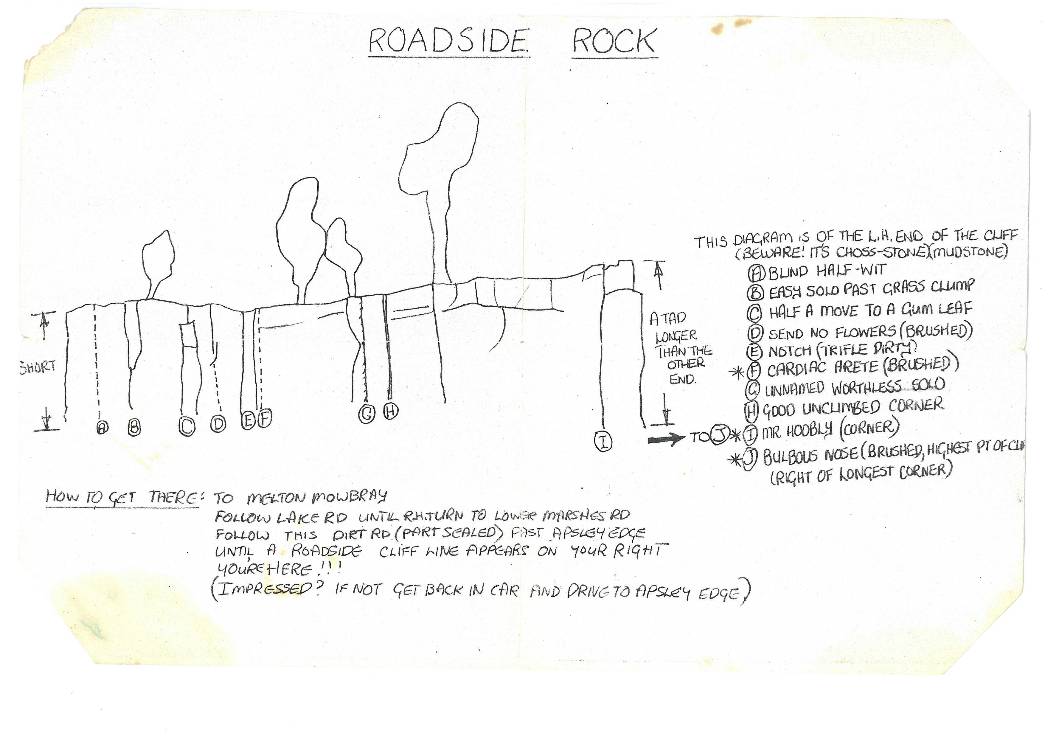
Face climb corresponding to the letter A on the sketch.
A. Adams and G. Cooper, 1986
An easy solo past a clump of grass that corresponds to route B on the sketch.
G. Cooper and A. Adams, 1986.
Climbs the conspicuous rock feature that corresponds to route C on the sketch. It is also marked on the topo.
G. Cooper and A. Adams, 1986.
A brushed line that leads to a crackline, that corresponds to route D on the sketch.
A. Adams and G. Cooper, 1986
The obvious notched feature that is a tad dirty, that corresponds to route E on the sketch.
G. Cooper and A. Adams, 1986.
Guaranteed to send your heart into a flutter! Takes the brushed arete just right of the Notch, that corresponds to route F on the sketch.
A. Adams and G. Cooper, 1986.
Further right is a worthless solo, that follows the line that corresponds to route G on the sketch.
G. Cooper and A. Adams, 1986.
Good Looking
Unclimbed to date, this project awaits the arrival of a new generation of desperado. Follows the good looking corner that corresponds to route H on the sketch. It is also marked on the topo.
This route might be the saving grace for visiting this crag, but don't get too excited. It follows the corner a fair way right of the previous route. It corresponds to route I on the sketch. It is also marked on the topo.
A. Adams and G. Cooper, 1986.
Another potential mega classic that awaits your visit! A brushed line climbs the the tallest part of the cliff, just right of the longest corner line to the right of Mr Hoobly. It is marked on the topo.
G. Copper and A. Adams, 1986.
Shag Bay
Shag Bay is a pile of choss, but apparently "was climbed out by Phil Steane in early eighties". No further details are available.
Sorell Creek Crags
There are three different small dolerite cliffs at Sorell Creek which were developed in the 1970s. They are in the gorge that the road which heads south from the Sorell Creek township goes through. They currently languish in obscurity, and will probably stay that way. But if someone is super keen, there are descriptions in the CCT circulars in the State Library.
The Rookeries
The Rookeries is an old dolerite crag on South Arm with access problems. There were numerous climbs done here in the early 80s and 90s by the Jacksons and they are in the process of collating and documenting these climbs, as well as reappraising the access. In the meantime they suggest that climbers do not climb there as access is still an issue.
Mt. Lloyd
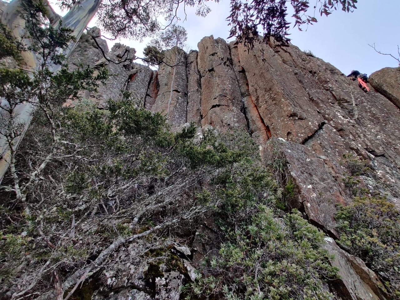
Christoph Speer and Fraser L-R investigated climbing potential on Mt. Lloyd in May 2022. The rock is flaky, chossy alpine dolerite and looks much better from the road than it does up close. A few routes were done on the Southern cliff-line (listed here), and there's probably a few more lines to do if you can be bothered going up there. Unfortunately, the larger Northern cliff below the fire tower is complete and utter choss.
You can access the cliff by driving to Mt. Lloyd and parking in a forestry coup just below the West side of the mountain. Following the pink tape from near the end of the forestry road, it's about a 45 minute walk up the hill through easy open scrub/bush to the top.
Mt. Lloyd South
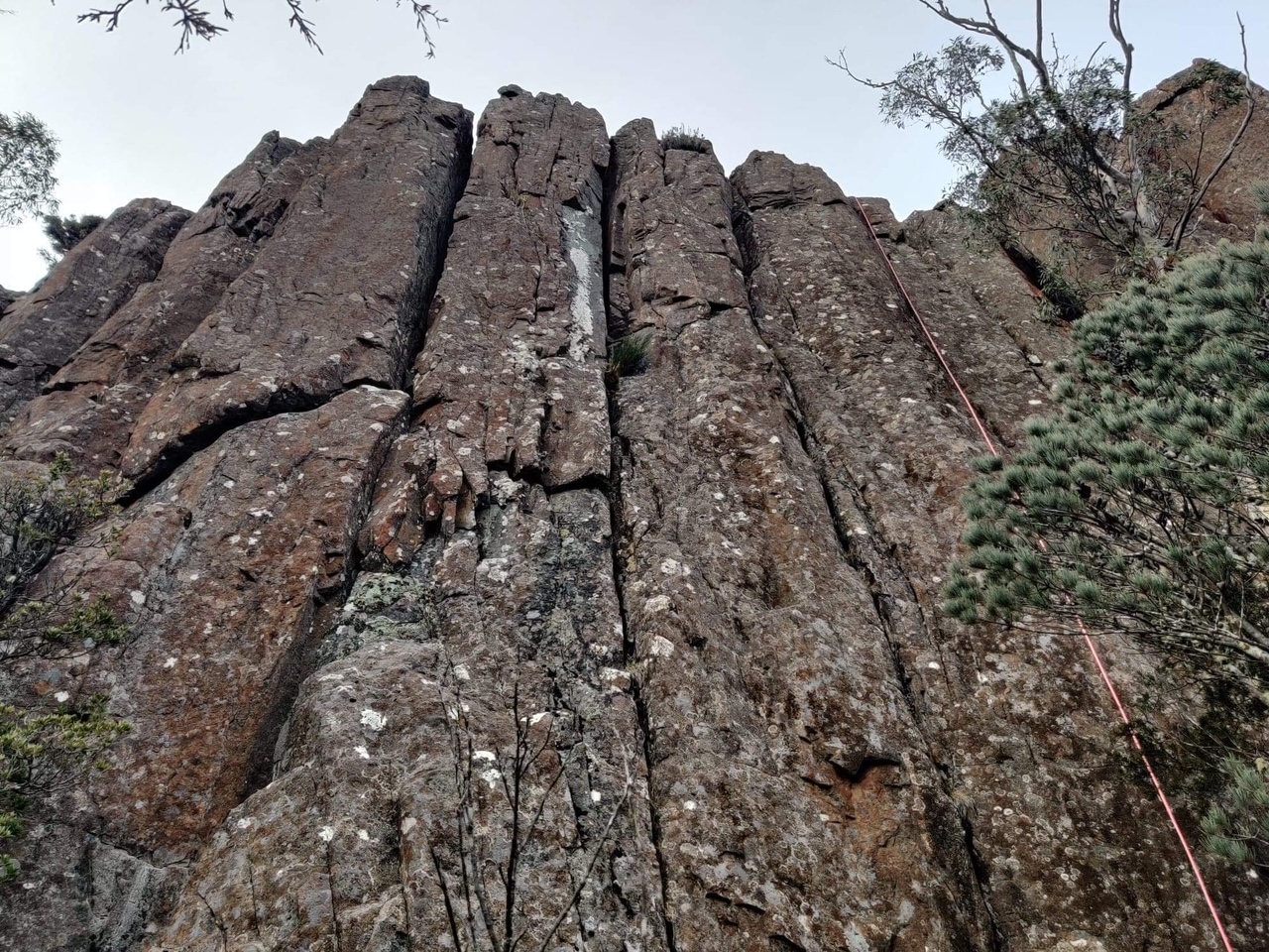
Mt. Lloyd South
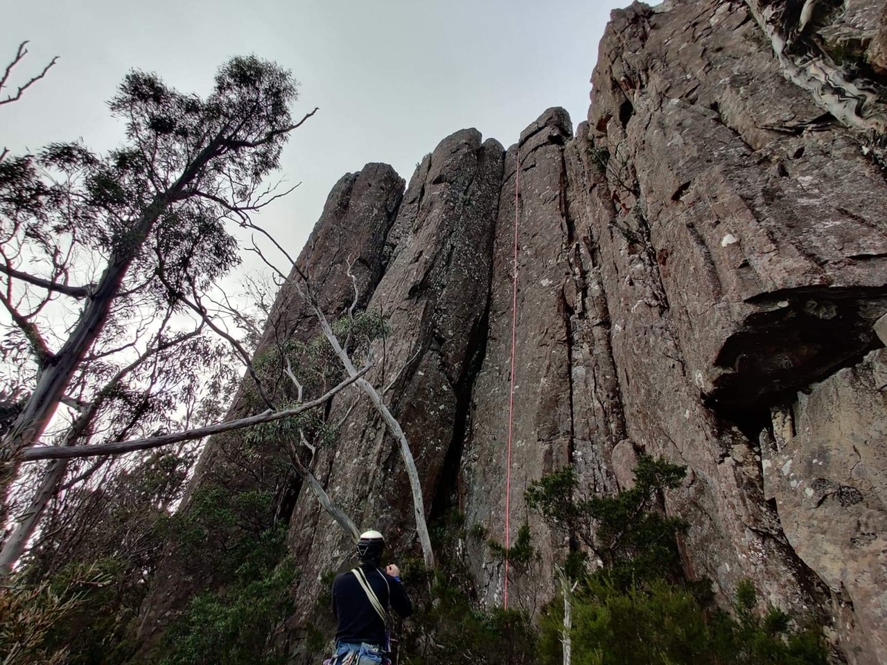
Mt. Lloyd South
Climbs the twin cracks in the corner.
Christoph Speer, Fraser L-R, May 2022
Climbs the slab, then up the line and into the wide crack.
Fraser L-R, Christoph Speer, May 2022
Takes the cleaned thin-hands splitter to the right of The Big Short.
Christoph Speer, Fraser L-R, May 2022
Takes the initial corner of Tax Deduction until you can move left into the crack on the arete.
Fraser L-R, Christoph Speer, May 2022
Climbs the nice open book corner crack.
Christoph Speer, Fraser L-R, May 2022
Rhyndaston Gorge (Colebrook Gorge)
The gorge at Rhyndaston has been explored by different parties on separate occasions for climbing potential. Large, vast sandstone cliffs exist in the gorge with easy access from the end of Youngs Road. Unfortunately, the sandstone is too soft and chossy for development and the cliff provides little value other than a nice picnic with your significant other.
Barren Rock (Dysart)
Barren Rock has been explored by various parties over the years, with Lewis and Closs probably being the first during the 1970s. The Jacksons put up one route here in the 1990s.
Christoph Speer had a recent look in July 2022 and reports the following: It is a large dolerite cliff with straightforward access from Harbachs Road and lies within the Devils Den Conservation Area. Unfortunately, the cliff is extremely lichenous and chossy. There may be potential for some trad and sport routes here but the amount of work needed to clean them makes them not worth the effort.
Also of note is that the swimming hole at Devils Dens is quite pleasant on a summers day (HJ).
Seemed to be most striking natural line at the cliff. Lichenous, slabby wall to rooflet at 10m, through this following finger crack, with difficulty.
H Jackson, M Jackson, A Vincent 1995