
Precipitous Bluff
 Four days tough walking
 Mixed sun and shade
 Columnar Dolerite, 400m high
Acknowledgement
Compiled from original material by Phil Robinson, Chris Rathbone, Steve Monks and Ross Taylor
Introduction
Located deep in the South West wilderness, Precipitous Bluff (PB for short) is an impressive dolerite peak, with a towering rampart of columnar cliffs facing out to the Southern Ocean. The problem of course is access as any prospecting climber faces at least four days walk in, and out, and has to brave the sometimes appalling weather.
History
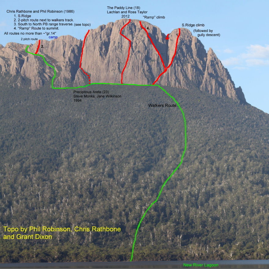
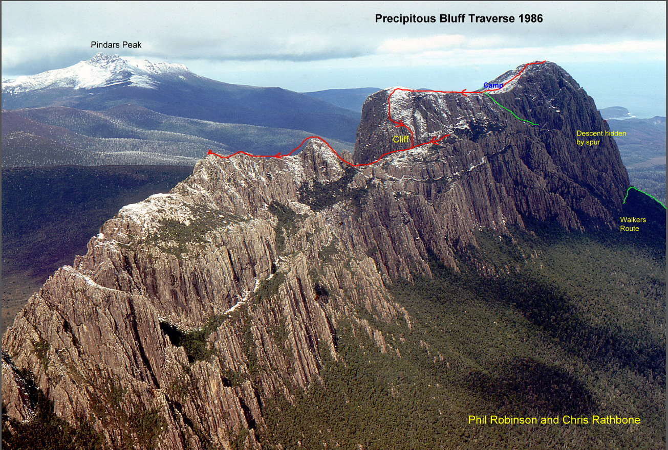
Nevertheless, over the years climbers have braved the elements and explored a little of the enormous potential of the area. Details are scant but it seems the peak was probably first climbed by Mac Urquhart in the 1930s. Dave Neilson from Melbourne is reputed to have visited and left a rope there in the mid 70s, but it isn't known what, if any, climbing was done. Phil Robinson, Tasmania's leading exploratory climber for many years, was there with Chris (Basil) Rathbone in 1986. "We climbed a good long ridge to the summit, some short routes but the main face had blank corners (needed pegs which we didn't have) like the E. Face of Mt Anne. We had hexs and wires and 2 or 3 original Friends but we never used to aid anything in those days. If it didn't go free there was always another line to try."
In 1994 visiting Victorian climbers, Steve Monks and Jane Wilkinson, undaunted by the out-there location and access problems, created a major multi-pitch wilderness climb, Precipitous Arête(23)committing themselves with the minimum of gear "a single 30m rope and a handful of wires".The next new route recorded was in 2012 where Lachlan and Ross Taylor hiked along the coast from Melaleuca, up the lagoon and added The Paddy Line (380m, 18),“the easiest looking line up the main face”
Access
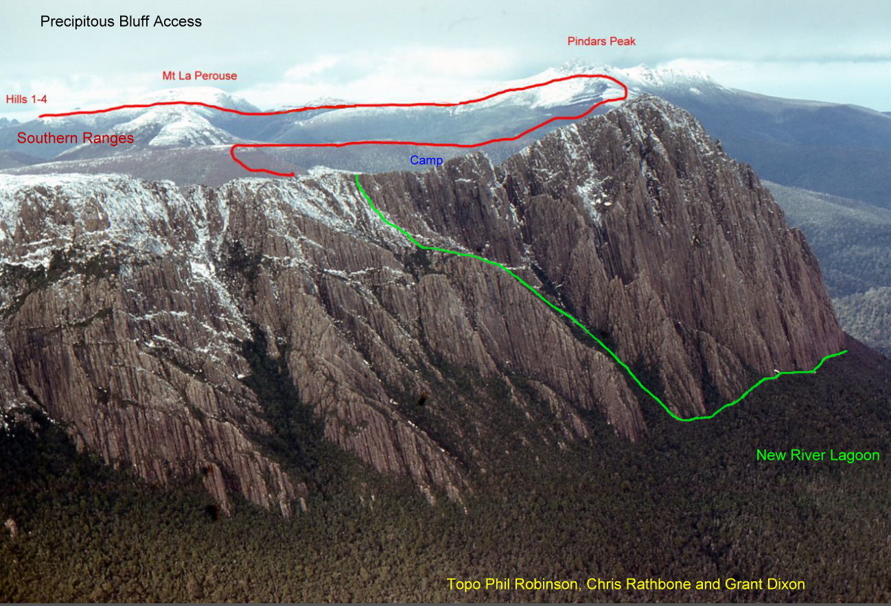
This is not for the faint hearted! Either (1) From Cockle Creek, follow the South Coast Track north for three days to New Lagoon, then wade up the river for another day to Damper Creek. From here, follow a taped "track" for maybe four hours up to the cliff line. The track turns north here and follows the cliff base to a major gully - this has been climbed (difficult) as a way to the summit but the main route continues on for about another hour, then up and round another narrow gully before climbing more easily up the ascent gully, exiting L when it ends and into the next gully which leads to the top. Descent is via this path.Camping is available at a rough campsite on the south bank of the Damper River (658850), or there is a small bivvy near a permanent pool about 15mins after the track turns north at the base of the cliffs. Or (2) Traverse the Southern Ranges for 2-3 days from Lune River via Moonlight Flats, Hills 1-4, Mt La Perouse and Pindars Peak. This is quicker than the South Coast track although very exposed. Camp at a semi sheltered hollow just below the summit. The best weather is usually February and March although you can expect lousy conditions at any time.
PB is in Tasmania's World Heritage Area and is a fuel stove only area. Full details on the South Coast Track, access and transport are available in John Chapman's South West Tasmania Guide, 2008. See also TASMAP 1:25 000 Precipitous and/or 1:100 000 South Coast Walks, and http://www.parks.tas.gov.au/recreation/tracknotes/scoast.html for track information.
Crag Steward
Rock climbers please contact the Cliff Steward (southwest@climbersclubtas.org.au) if you have any queries or concerns regarding social or environmental impacts of rock climbing at this crag. Do not email regarding general travel, seasonal advice, or lost property - this is not the Steward’s role. If you have important safety information to communicate (e.g. risks due to recent and large rock falls) please also consider updates on thesarvo forum, facebook group and/or online guidebooks as appropriate. Please copy in cct@climbersclubtas.org.au if you feel you have a high level concern which may imminently impact the crag or climbing community.
Non-climbers, other users, land managers: please also contact cct@climbersclubtas.org.au if you have important climbing related queries at this location.
Summit Buttress
Precipitous Arête
265m23Steve Monks, Jane Wilkinson 9 Feb 1994
The Paddy Line
370m+18Lachlan & Ross Taylor (alts), 14/2/2012