
Walls of Jerusalem
 3 hours uphill walk
 Mixed sun and shade
 Alpine dolerite
Acknowledgement
Compiled by Tony McKenny from CCT circulars, with additional information from Peter McHugh, Peter Jackson and Geoff Batten.
Introduction
The Walls of Jerusalem National Park is located on the northwest edge of the Central Plateau and consists of five main dolerite peaks with a wide open grassy plateau between, dotted with small tarns, glacial moraines and pencil pine groves. It forms part of the Tasmanian Wilderness World Heritage Area and is a mecca for local and visiting bushwalkers. The environment here is particularly fragile so please stick to the principles of minimum impact bushwalking and climbing (no bolting for example). This is also a “stove-only area”.
Access
NB The road to the Walls (Mersey Forest Road) is closed beyond the intersection with Lake McKenzie Road due to a washout (Aug 2016). The closure affects access to Lakes Rowallan and Parangana and the access hiking tracks into the Walls of Jerusalem and Lees Paddocks, and the Arm River Camp/Track. Repairs may take up to two years...
For queries on road/track closures call Great Western Tiers Field Centre on 03 67012104 or Forestry Tasmania on (03) 6350 6466.
From Deloraine, follow the B12 through Mole Creek and take the Mersey Forest Road (C138, then C171) to Lake Rowallan. A gravel spur road on the L just after the Fish River leads to the carpark. From Devonport, follow the B14 south for 31km to Sheffield and take the Claude Road (C136) towards Gowrie Park. About 7km further on, turn L onto the C138 and head south for about another 20km till you join the Mole Creek Road and the C171 to the Walls. Don’t leave valuables in parked vehicles as break-ins have occurred at the Walls of Jerusalem car park. There is no public transport to this park.
Follow the Horse Track up through wet sclerophyll forest for about one hour to the re-built Trappers Hut and continue up on a well constructed track past the Solomons Jewels to Herods Gate at the western entrance to the main valley of the Walls, about two hours from the road head and about 6.6km in distance.
To the right is the towering West Wall, topped by the highest peak in the Central Plateau area, King David’s Peak (1499m). For the Damascus Gate, continue for about another 3km across the marshy plain and climb up about 500m to the track junction at the Pass.
Camping is restricted to the hardened camping platforms at Wild Dog Creek (toilet provided), just before entering Herods Gate. Huts are in poor condition and are suitable for emergency shelter only. A National Parks Pass is required by all visitors to the area.
For further information, see Walls of Jerusalem Map and Notes (TASMAP 1:25 000), "Day Walks, Tasmania" and/or "Cradle Mountain Lake St Clair, and Walls of Jerusalem National Parks" (2009), both by John Chapman, Monica Chapman and John Siseman, or the Parks and Wild Life Service web site: www.parks.tas.gov.au
Crag Steward
Rock climbers please contact the Cliff Steward (southwest@climbersclubtas.org.au) if you have any queries or concerns regarding social or environmental impacts of rock climbing at this crag. Do not email regarding general travel, seasonal advice, or lost property - this is not the Steward’s role. If you have important safety information to communicate (e.g. risks due to recent and large rock falls) please also consider updates on thesarvo forum, facebook group and/or online guidebooks as appropriate. Please copy in cct@climbersclubtas.org.au if you feel you have a high level concern which may imminently impact the crag or climbing community.
Non-climbers, other users, land managers: please also contact cct@climbersclubtas.org.au if you have important climbing related queries at this location.
West Wall
Shibboleth
120m13Jack Prowse, Lawrence Wonhas, Nov 2023
Pythagoras
75m12?Takes the RH of two prominent diagonal lines on the West Wall, about opposite the Pool of Bethesda.
P. amd C. Hekman, 1968.
Judas
14Follows a prominent crack line on the RH side of the large scree couloir centrally situated on the West Wall. Loose.
M. Tillema and G. Batten 1968.
The Buttress just to the L (south) of the scree slope was attempted by K. Sparreboom and M. Douglas about the same time.
Magdelena's Crack
78m15?G. Batten and M. Tillema, Easter 1969.
Esau
85m12?Climb the prominent cleft in the northern end of the Damascus Buttress (i.e. that part of the West Wall above Damascus Gate). The obvious crack line leads to a ledge about three quarters of the way up. From the ledge there are two options - the somewhat tricky dark wall or the chicken run up a chimney to the right of the dark wall.
G. Batten and M. Rockcliffe, Easter 1968.
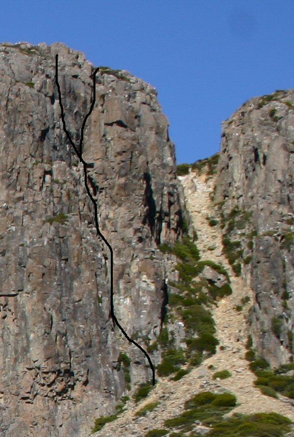
Esau Varient
85m12?Takes a line up the sub-buttress alongside the cleft, then finishes up Esau.
G. Batten and M. Tillema, 1968.
Kneebone of an Ass
50m18D. Gilliatt and P. Dolan, 3 Feb 1989.
East Wall
There is one recorded climb on the East Wall, on the discontinuous buttress below the south summit of the Wall, in a scrubby gully.
Ogwen
100m14Peter Jackson and Noel Ward, Dec 1983.