
The Western Arthurs
 One to two days hard bushwalk
 Mixed sun and shade
 Alpine quartzite, up to 350m high
Acknowledgement
Compiled by Tony McKenny based on original information compiled by Jon Tiller and the Jackson brothers. Thanks to Phil Robinson for the photos and additional information.
Introduction
The Pre-Cambrian quartzite of the South West has been etched by glaciation and weathering to form one of the most impressive ridge lines in Australia, with many spectacular narrow ridges, deep cirques, distinctive moraines and of course, steep rock faces. The setting is awesome, with jagged, beautifully twisted rock architecture, and picturesque hanging lakes below. It has been said that there is more unclimbed rock in Tasmania than in all the other States put together, and much of this is in the South West, and in the Western Arthurs in particular. This climbs describe here represent only a fraction of the possibilities.
In general, the rock is fairly difficult to protect and a bit loose in sections, but this is not always the case. The featured nature of the rock results in lines going at easier grades than one would expect from the ground. The underlying strata of the rock seemed to slope down on the NE side of the range and up on the SW side making for `harder' and `easier' climbing respectively.
Climbing on the Western Arthurs is a serious undertaking. The Range is very exposed and climbers can expect the worst weather in the South West. In summer, snow, hail, wind and rain may alternate with sunny days and calm conditions, so be prepared. Rescue in event of a mishap would be difficult and lengthy – carrying an EPIRB is recommended.
The Western Arthurs are included in the South West National Park and form part of Tasmania's World Heritage Area. Please respect the wilderness and stick to the principles of minimal impact bushwalking. The WHA is a fuel-stove only area and a general Parks entry permit is required.
NB Treat the accuracy of any of the information in this guide with caution, as descriptions are often based on a single ascent. This is generally recognized as a “bolt-free” area; climbers are asked to respect local opinion on this one (and it is of course illegal!).
History
The climbing history of this area is incomplete. Climbing exploration has occurred since at least the early 60s but no records appear to have been kept, nor any photos published, except for the more accessible northern end of the range. Most of the information available comes from a series of trips in the mid seventies involving Phil Robinson who has pioneered many new lines here and in other remote areas, and the Jackson brothers, Marcel and Hamish, some twenty years later. The rest of the range, with its many mountains and cliffs, awaits the exploring climbers of the future – adventures waiting to happen!
Access
By far the best information about the access and walking tracks is found in South West Tasmania by John Chapman, the latest edition is to be published June 2008. See http://www.john.chapman.name.
As of 2022, there is a permit system in place for people undertaking overnight trips here. See:
https://parks.tas.gov.au/explore-our-parks/know-before-you-go/overnight-walker-registration
From Hobart, follow the main road (A10) west through New Norfolk, and then the B61 to Westerway and Maydena. Continue on towards Strathgordon but turn L at Frodshams Pass onto the C607 to the Scotts Peak Dam, 154 km from Hobart. During summer a small bus operates 4 days each week to the Dam. During other seasons, a service runs once a week if there are bookings: see http://www.tigerline.com.au/
The area covered by this brief review is restricted to the north end of the ridge as the popular Moraines A to E circuit is extremely convenient for climbers (by southwest Tassie standards anyway), with either end of the circuit being accessible within a day’s driving and walking. Access to the south end of the ridge is usually from Cracroft Crossing via the Huon Track and the south end of the Arthur Plains Track.
From the Scotts Peak Dam, follow the Arthur Plains Track south to Junction Creek, an easy half day on a well-benched if muddy track. From here, turn west onto the Port Davey Track or east onto the Arthur Plains tack..
Moraine A: the shortest way to the north end of the ridge and accessed from the Port Davey Track, about 2 km west of Junction Creek. A long haul up the moraine leads to the ridge top, then follow the ridge south past Lake Fortuna to Lake Cygnus (4-6 hrs).
Moraine E: a longer route from the Port Davey Track, starting a little west of the Arthur Plains Track junction and giving access to the "mid-north" end of the range (Mts. Hayes, Procyon and Orion, and Square Lake). Most often used as a means of exiting the ridge. To climb the moraine from the Plains, head for Two Mile Creek (GR 418252) from the track junction, and head up the fairly obvious ridge. (3 – 4 hrs).
Moraine K: provides access to the range from Seven Mile Creek on the Plains Track but is also a good exit point from the range as well. Gives access to Mt Scorpio and lakes Veta and Juno. To climb the ridge from the plains, leave the Arthur Plains Track at Seven Mile Creek and follow the plains south-west keeping between two creeks to the relatively easy and distinctive ridge of the moraine.
Maps: Tasmap 1:100 000 Old River.
Camping
More and more bushwalkers are now visiting the Western Arthurs and camp-sites may be full in high season (Dec – March). Please use the camping platforms provided and refrain from cutting any new sites in the bush. Most camp sites are quite exposed. Camp-sites on the way in: Scotts Peak Camp (GR 438348), and Junction Creek (GR 411278). There is also an exposed camp-site at the start of Moraine A (GR 388271). Camp-sites for Mt Hesperus and Capella Crags: Lake Cygnus. Campsites exposed but better than Lake Fortuna. Campsites for Mt Hayes, Procyon Peak and Square Lake: Square Lake (GR 398229). There is also a neat bivvy cave near the top of Moraine E, dry and sleeps four.
Crag Steward
Rock climbers please contact the Cliff Steward (southwest@climbersclubtas.org.au) if you have any queries or concerns regarding social or environmental impacts of rock climbing at this crag. Do not email regarding general travel, seasonal advice, or lost property - this is not the Steward’s role. If you have important safety information to communicate (e.g. risks due to recent and large rock falls) please also consider updates on thesarvo forum, facebook group and/or online guidebooks as appropriate. Please copy in cct@climbersclubtas.org.au if you feel you have a high level concern which may imminently impact the crag or climbing community.
Non-climbers, other users, land managers: please also contact cct@climbersclubtas.org.au if you have important climbing related queries at this location.
Mt Hesperus
The cliffs of Mt Hesperus form two tiers, with one tier easily visible from the Moraine A walking track, and the other heading off, almost at right angles, south of these. From the summit, this first set of cliffs are below to the left, and the second set easily visible dropping off to the right. Access this first set from just 50m west of the summit by heading down the obvious gully. The second set are accessed from the saddle immediately above and east of Lake Fortuna. Apart from some short patches of dense pandani at the second cliffs, in neither case is the approach difficult.
A line on the cliff directly beneath the summit of Mt Hesperus (the first set), accessed by a descent down a gully west from the summit, then north to the foot of the 180m walls. Takes the easiest line up a buttress from the foot of the wall, climbing down-sloping, glassy quartzite for 100m, followed by a loose red overhanging section. Above the overhang, a thin line leads off to the L to an escape in the gully.
P. Robinson, B. Rathbone 1978
Difficult to find (if you do find this climb, you will probably be the second lot of people to walk on this piece of space). From the saddle east of Lake Fortuna, the cliffs extend northwest for 200 - 300m until a very rocky ridge (the top of moraine B) meets the mountain (in fact some of the first set of cliffs drop off from the other, northern side of this ridge). About 2/3 of the way to this ridge, the cliff line heads up hill, shortly after which a smaller buttress/arête is visible with interesting folding in the rock and a base clear of scrub. Standing at the base of this arête, Lake Neptune should just be disappearing from view behind the ridge to the southeast. Climb the arête and face of this with frustrating pro and rock.
M. and H. Jackson, 1996
Capella Crags
These west-facing cliffs offer remarkable access, sitting only a hundred metres from the Lake Cygnus campsite and in some places even overhanging the track itself. The general atmosphere of the lake and its surrounding crags make for very pleasant climbing.
A direct line on Capella Crag above Lake Cygnus.
P. Robinson, B. Rathbone 1978.
On the furthest right of the cliffs is a smaller detached buttress sitting high on the skyline. Apparently, legend has it that in an other time, a lone bush ranger used this crag as a hide out to ambush passers by on the track below. The climb: Start on the E face of the detached buttress, quickly heading L around the arête to the overhanging face. Take the line diagonally left through the steep section then more easily up cracks to the top. Entertaining climb, but a little dangerous.
H. and M. Jackson, 1996.
Starts near the gully 15m further up (SE) from the section of the cliffs that overhangs the track. Climb the left arête of the gully (pitch 1) – a few metres right of the right-facing corner – and then the open face above and right (pitch 2). Excellent rock up probably the longest continuous part of the crags. A very rewarding climb on a sunny afternoon. Descent can be made via a gully off the back right.
M. and H. Jackson, 1996.
Off-widthy sized vertical crack thing - 5m right of western most face. A bit of a dirty start and slightly overhung in some places. Up to prominent ledge.
N. Morgan, B. Armstrong Feb 2015.
Mt Hayes
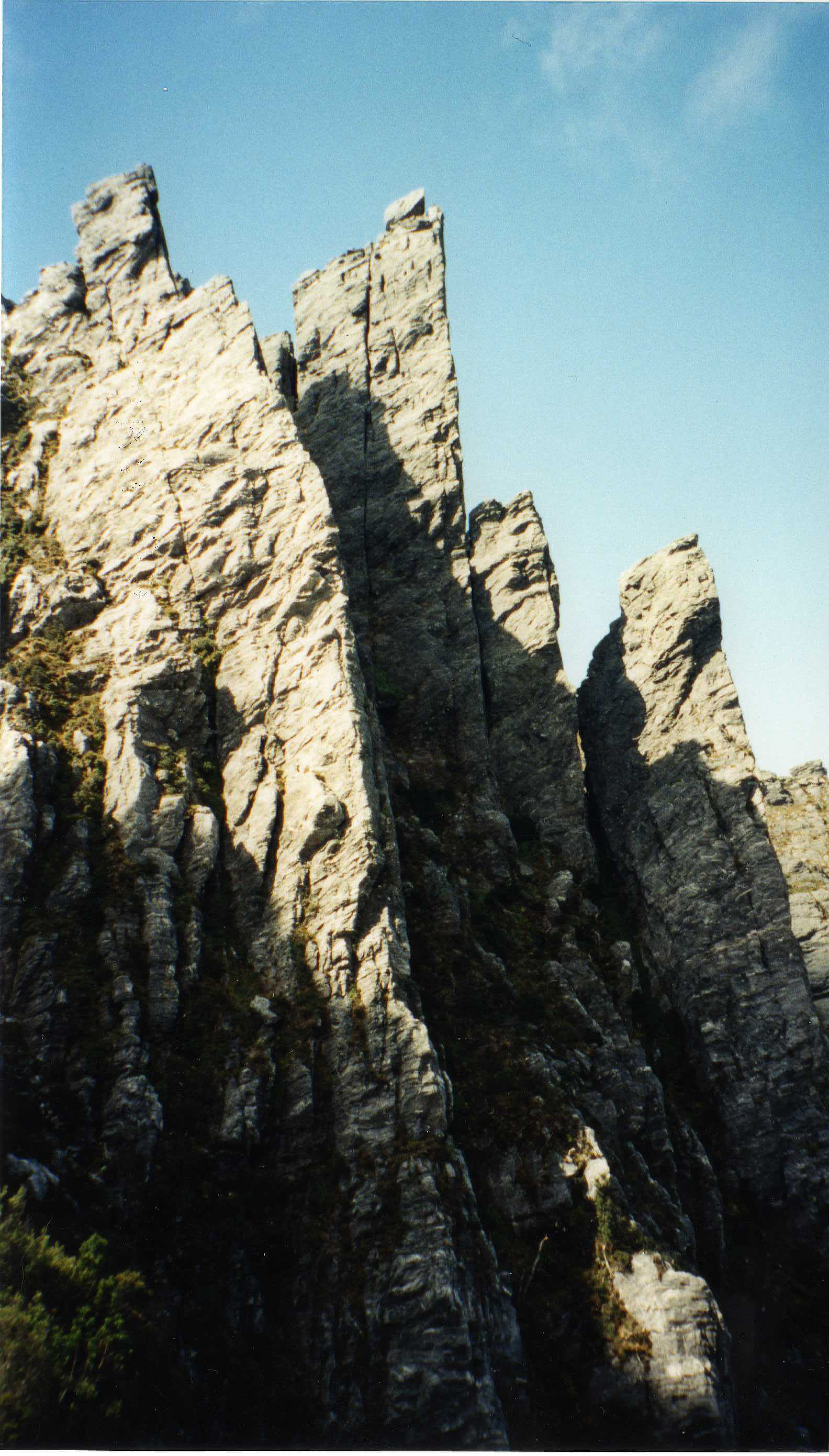
There is a very large amount of rock all over Mt Hayes. Some large (perhaps 200m+, though sometimes a bit broken), but less accessible cliffs are waiting off the eastern sides. The cliffs climbed on are near the track, which goes round the western and southern slopes of the mountain. After sidling around the south of the summit, the track quite suddenly heads down very steeply below a severely overhung arête. About two thirds of the way down the hill to the saddle two major features are apparent to the east, back toward the peak: a very sharp arched fin of rock and an impressive square tower to its right (the arête overhanging the track further uphill is to the left of the fin from here). The following climb takes the sharp fin.
Mt Hayes
Access the base of the rock fin via an easy solo in from the right. Climb the superbly sharp (about 20°!), improbable looking arête in an awesome position.
H. and M. Jackson, 1996.
Procyon Peak
S.W. Side
As Procyon Peak is approached from the west a large outcrop on its south-western slopes is easily visible (indeed the track passes about 80 m below its base). The cliff is between 80m and 100m in height and about 100 - 200m long. On the far left is an enticing left-facing corner which is the line of the following climb.
1. Climb the corner and left face to a good ledge at about 35m. 2. Continue up the daunting corner climbing the left face on excellent rock until a classic exit must be made across the steep right wall right at the top.
H. and M. Jackson, 1996.
The following climbs are best accessed from the bivvy cave high up on Moraine E.
The wide crack to the L of the Bivvy Cave, easier than it looks with adequate protection.
Mark Chin.
S.E. Side
Start: Scramble up the most northerly gully on SE side of Procyon Peak. 1. 23m. Up 5m crack to ledge. Follow nose of rib to large mossy ledge. 2. 37m. Traverse R into pineapple grass gully. Move back onto rib after 6m, continue on nose until the angle eases.
P. Robinson, G. Kowalik 1975.
N.E. Face
The 350m face on the NE side of Procyon Peak is split by two vegetated ledges more or less at an equal distance apart. There is one obvious line, from bottom to top, which climbs the lower 115m, and the top 130m.
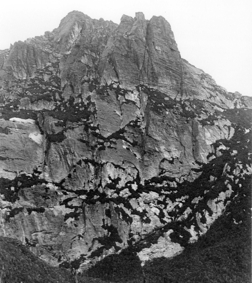
Start: Drop down into the scrub-filled gully below the bivvy cave to foot of the face (45mins.) The start was marked by a cairn (in 1975!) Lower section: 1. 40m. Surmount obvious crack, move up the slabs to knife-blade belay. 2. 43m. Up 5m through the scrub and trend R on slabs to base of main corner. 3. 10m. Scrub scramble. Top Section: Start at the base of the RH chimney with a large chockstone 10m up. 1. 20m. Up chimney and over the pineapple grass ledge. 2. 38m. Traverse R onto the face and continue straight up. Exposed climbing to a semi-hanging belay. 3. 37m. Continue vertically up the face on good rock but with poor protection. Belay on the grassy ledge. 4. 20m. Up short wall and traverse diagonally R to short overhanging section. Belay on large ledge. 5. 15m. Up crack for 8m, round RH corner and straight up wall to summit.
P. Robinson, G. Kowalik 1975
N.E. Face Proycon Peak Headwall
Start: Two large chimney cracks split the middle of the face. Follows the prominent LH crack, L of Wild Boar. From the base of the LH crack, move further L for a few metres to a prominent short crack for a more interesting start. 1. 18m. Straight up for 5m, negotiate overhang using the crack, trending R to ledge above the L of the two chimney cracks. 2. 46m. Continue up chimney crack into a large grassy gulley. 3. 12m. Move L onto face and climb up on small holds and even smaller runners... either walk off up scrubby gully or climb the vertical corner to make a pitch 4 (not completed).
P. Robinson, C. Rathbone, M Chin 1976
Left Chimney Crack
The Left Chimney Crack which crosses the Hobart Route at the top of Pitch 1. Then follows a hand-traverse to the R which is followed by a steep chimney-corner with little protection.
P. Robinson, C. Rathbone, M Chin 1976
Start: at the RH end of the face are two chimney cracks which join at 20m. The Hobart Route takes the RH chimney. 1. 23m. Up chimney to ledge. 2. 43m. Up chimney then the crack to a large ledge with an enormous boulder. 3. 21m. Traverse L along ledge up the exposed face – mind blowing – to pineapple grass ledge under a big overhang. 4. 30m. Up chimney to the L of the overhang. 5. 37m. Traverse L and up short steep pitch to large ledge where the route actually crosses Wild Boar. Continue L up short overhang to another ledge, then up final nose to the top.
P. Robinson, C. Rathbone, M Chin 1976.
Square Lake
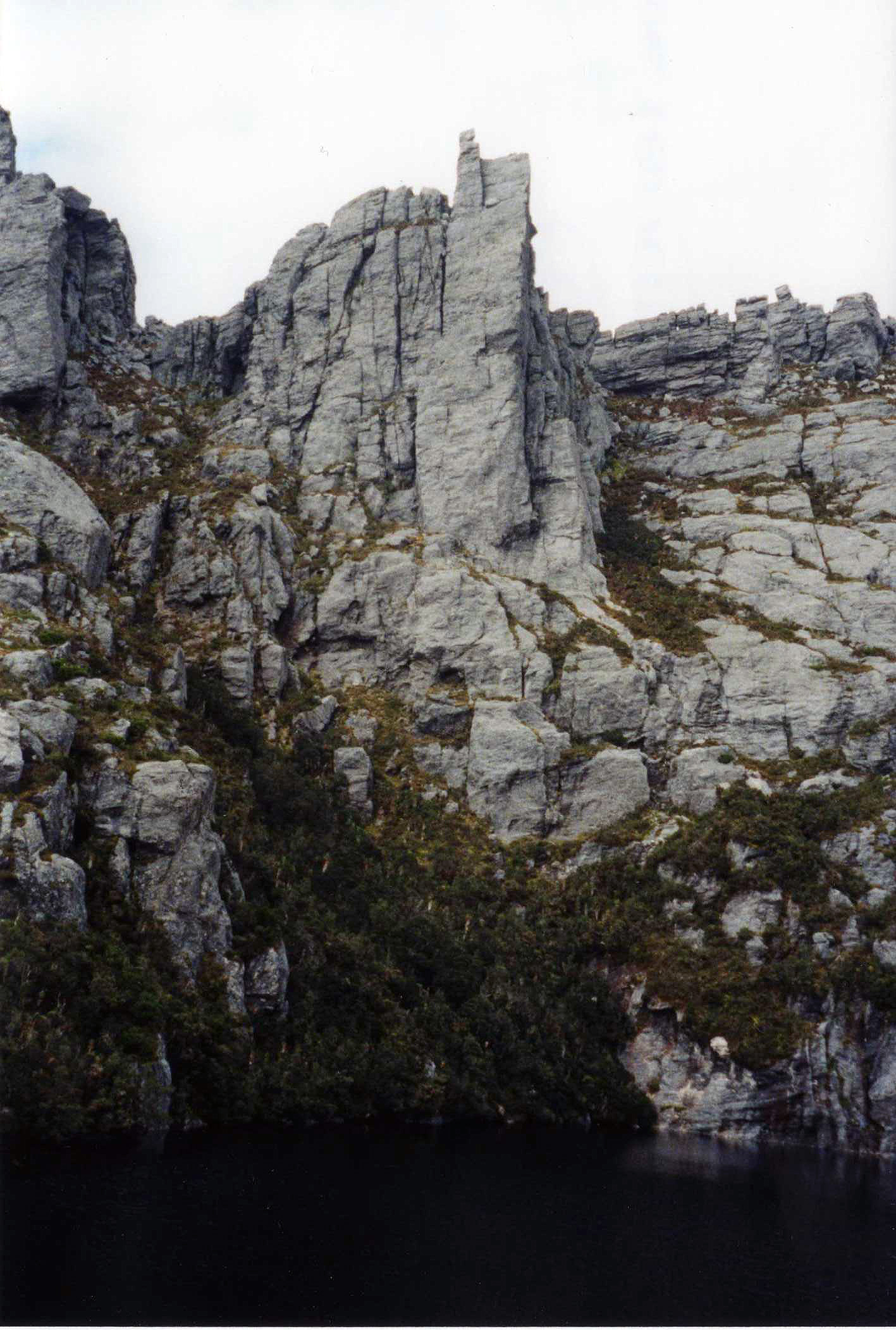
Square Lake is nestled in a dramatic position below Procyon Peak, Mt Orion, and Mt Sirius. This is a good spot to access many good cliffs. From the outlet creek where the track meets the lake, the most obvious cliffs are a large set entering the water opposite and a huge tower hanging high above the back left of the lake.
Square Lake
This is the tower on the left. 1-2. The face on the front of the tower is initially overhanging but an obvious corner and chimney system on its east face provides pleasant climbing on good rock to the ledge on the front at about half height. 3. From here the tower is easy angled, and the easiest way up takes the incredible right arête which can be followed until the ledge just below the summit. 4. Finish up the classic and very easy corner to the top. Excellent climbing, way above the black waters of the lake - maybe the best route on the range.
H. and M. Jackson, 1996.
Lake Oberon
Soon after passing Square Lake, the main track ascends steeply to a saddle between Mt Orion & Mt Sirius before descending down to picturesque Lake Oberon. There is potential for some longer routes here in the surrounding vicinity, and a few smaller crags have previously been climbed featuring some OK climbing.
High Moor
After skirting Lake Oberon, the tracked walk becomes significantly more difficult & less distinct in nature - as it pushes across the most scenic sections of the range. It's a tough 5 - 8 hour slog before you reach the campsites at High Moor. Some steep climbing on short blocks is possible alongside the track between Mt Pegasus & Capricorn, and there is some interesting rock formations in the area around Mt Columba.
High Moor
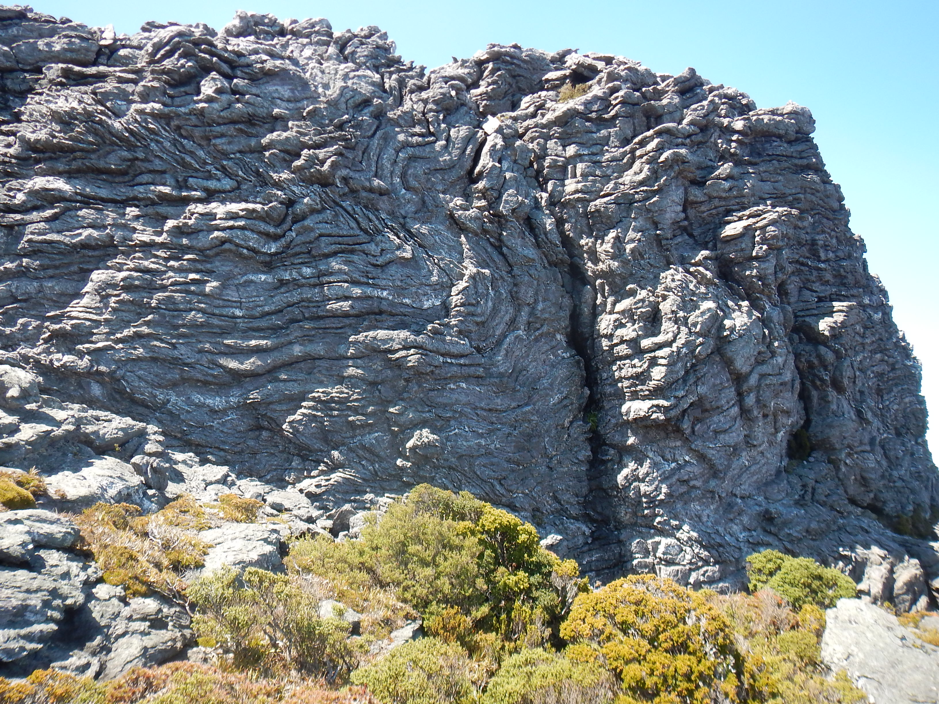
There is a funky block of highly featured folded rock on the false summit of Mt Columba, directly above the track as you approach the High Moor area. The cliffs on the SW face provide steep, juggy climbing with absolutely mind-boggling views back across the range. Short fun cragging - pick your own adventure.
Start at the back of the chasm at the LH end. Climb up to ledge, then follow the RH trending traverse line.
B. Armstrong, N. Morgan Feb 2015.
Starts 4m L of "So Long, Big Red" break, following a series of flakes directly to the top. Good climbing.
N. Morgan, B. Armstrong Feb 2015.
Below LH chimney/break, and up onto the RH side wall. Finish diagonally left up major crack line.
N. Morgan, B. Armstrong Feb 2015.
Persistently steep. Start in front of two boulders on 3m high ledge - 5m R of RH jaggered break in cliff. Continue straight up to the thinner extremity of a step around half way. Finish steeply just R of block at the top.
N. Morgan, B. Armstrong Feb 2015.
Start at undercut prow L of cave on the RH end of the cliff. Head directly upwards through some bulges. Search out those yummy jugs.
B. Armstrong, N. Morgan Feb 2015.
Haven Lake
In good weather, Haven Lake is a nice spot to hang out for a couple of days. There is a ton of rock in the area, but the scrubby approaches may not be so pleasant.
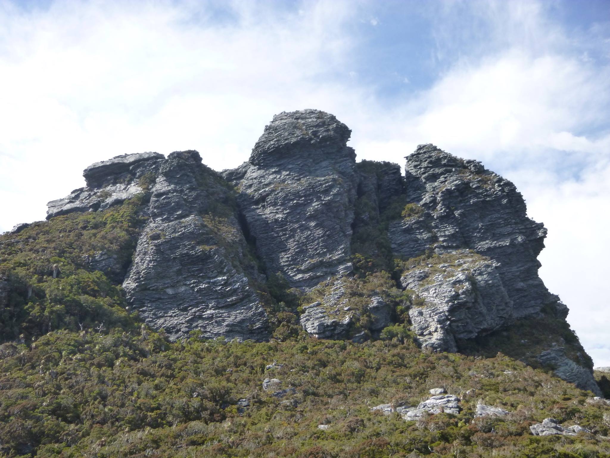
Haven Lake
A direct line up the central block of the cliffs, just NW of Haven Lake. Scrub bash across from the track, following a slight crest, before scrambling up onto a ledge. 1. 27m - Start near the RH edge of the frontal cliff and head straight up to a horizontal step. 2. 23m - From step, head steeply upwards through a succession of sharp plates to an easy roof, & finish just R of a grassy crack. 3. 40m - Continue easily across slabs to summit.
N. Morgan, B. Armstrong Feb 2015.