
Federation Peak
 2 days tough bushwalk
 Mixed sun and shade
 Alpine quartzite, similar to Frenchmans Cap
Acknowledgement
This guide to Federation Peak is based on the 1969 CCT Guide written by Reg Williams and updated by Tony McKenny. The old guide used English grades and where the grade of a route is not certain, the old grade has been included for reference: treat all grades given with suspicion. Thanks to Tim Chappell, Richard Eccleston, Lyle Closs, Mendelt Tillema, Phil Robinson, Grant Dixon and John Burgess for their contributions. The accuracy of any of the information in this guide should be viewed with caution, as descriptions are often based on a single ascent.
Introduction
Federation Peak in Tasmania's remote South West has been described as 'Australia's premier mountain - a true rock spire of high calibre and soaring proportions'. It is home to Australia's longest climbs, up to 700m, on excellent featured white quartzite. Although Federation has attracted many would-be climbers over the years, few actually summit each season due to the peak's technical difficulty, the arduous approach and the area's notoriously bad weather.
A trip to Federation is certainly not just another day at the crags - it involves a commitment to an expedition of at least 5 days, and the risk that no climbing will be done due to bad weather. Be prepared for an adventure. Taking an EPIRB is not a bad idea as rescue is a long way away.
Federation Peak is part of Tasmania's World Heritage Area, so please respect the wilderness and stick to the principles of minimal impact bushwalking and climbing (no bolting for example). The WHA is also a fuel-stove only area.
History
Deep in the South West wilderness, steep and technical on all sides and composed of quality quartzite, any ascent, whether by a bushwalker or a climber, is a significant achievement. To just climb the mountain, let alone do a new route, requires food, fuel, a lot of gear, fitness and skill, good weather... and time; time to walk in and out, time for reconnaissance and time to sit out the often atrocious weather. The early explorers relied on air drops of supplies to buy themselves that time - the 1951 team had 55 food tins airlifted in to them! After air drops were banned in the early 70s, subsequent parties have had to carry everything in; trips have had to be shorter and inevitably the number of new routes has dwindle dramatically.
It was only after many years of exploration and failed attempts that the mountain was actually climbed, when a Victorian group led John Berchervaise summited in 1949, so establishing the first rock climb on the mountain, the Climbing Gully (12) from the Bechervaise Plateau. Just a couple of years later, a determined group of seven climbers from the Melbourne University Mountaineering Club based themselves on the mountain for 45 days in all, exploring the range, locating the Forest Chute and, climbing in nailed boots, adding six new climbs to the Pinnacle itself.
A decade after the initial expedition, Victorians were back, with Bob Jones, Jack O'Halloran, Geoff Shaw, and Rob Dunse climbing the magnificent North West Face route (17) in 1961. The mainlanders continued to push new lines; Reg Williams, with Chris Baxter and Rob Taylor, explored the NE Corner (14) in 1965, while the ascent of Blade Ridge (17), over 400 metres of steep, unrelenting quartzite, by Peter Heddles, Rod Harris, David Neilson, Jack Woods in February, 1968 was sensational.
On a CCT trip in 1971 Bryan Kennedy and Lyle Closs added Two Pools on the Bechervaise Face, and Lyle returned in 1972 with West Coast underground miner, Karl Prinz, climbing Carlyle on the NW Face and making the first route on the West Face, the Wild West Route. In addition, John Davies and Neil Davidson added 'Davies and Wilbur' on the Jagged Wall to the right of the climbing gully to the summit.
Karl was back a year later with Geoff Batten, Ross Nicholas and Mendelt Tillema. He and Mendelt did a new route on the NW face following the crack/chimney on the right hand side of Blade Ridge, and Karl tried a new route directly up through the overhang (now the Direct Route), but had a fall about 15m up. He pulled out a few pieces of protection but they finally held before he hit the ledge. One foot was completely stuffed with severely strained and torn ligaments while the force and the friction had completely stripped the sheath on one of the ropes. After an epic abseil retreat, including a desperate climb and crawl up about 700m of the steep rocky couloir to get to Thwaites Plateau, Mendelt was despatched to race out to summon the S&R chopper.
Reg Marron, John Croker and Keith Egerton continued the mainland drive in 1979 with the hard North West Face Direct (18). Joe Goding and Simon Dadley-Moore added Joe and Simon Go Gardening (18) in 1996 , maybe not the most romantic of names but certainly, the most descriptive. Locals Tim Chappell and Richard Eccleston yomped in mounds of gear in 1997 to be rewarded with the hardest route to date, the North Face Route (19).
The mountain can appear truly alpine in winter, although conditions can be extremely variable due to it's relatively low height and position in the very wet "Roaring Forties". The first ascent under true winter conditions was made by Faye Kerr and Max Cutcliffe in September 1954, while a Tasmanian group led by Kevin Doran climbed the Mountain in atrocious conditions over two weeks in August 1978, a trip which cost Kevin a toe from cold injuries.
Access
Maps: TASMAP 1:100,000 Old River For more detailed access information see John Chapman's excellent book 'South West Tasmania', 1998, which is usually available in Hobart outdoor shops. The quickest approach to Federation peak is from Farmhouse Creek via Moss Ridge. Bechervaise Plateau can be reached in one very full day of walking, or more reasonably in a day and a half. This "route" is not marked on current maps, nor is it maintained in any way as a track. Various other approaches exist including the traverse of the Eastern Arthurs, see Chapman for more details.
The road to Farmhouse Creek and the cutting camp track re-opened in 2022 after a period of closure due to bushfire damage. However, the Farmhouse Creek bridge has now been removed and the carparking area is now 7.5km further back from the old carpark.
The Eastern Arthur traverse and Yoyo track appear to be now open but contact Sustainable Timber Tasmania, (03) 6169 2800, or Parks Tasmania for updated information.
To reach Farmhouse Creek: from Hobart head south on the Southern Outlet (A6) to Kingston, then on to Hounville and Geeveston. As you approach Geeveston, leave the Huon Highway on the Arve Road (C631). This is followed for 27km, ignoring side roads, to the road junction 1km before the Tahune Airwalk. Turn left onto the signposted 'Picton Road' and follow to the new road head.
To check which roads are open, visit or phone the Geeveston Information Centre (0362971836) before driving in.
From Farmhouse Creek follow the track for 18km (9-12hours) to Cutting Camp where good campsites exist. There has been a large number of trees blown down on the track and progress can be slow. From here it is a very steep and muddy slog up Moss Ridge, taking 4 to 6 hours to reach Bechervaise Plateau. From Bechervaise Plateau the Southern Traverse may be followed to reach the western campsites. If you are walking out via the Eastern Arthurs, allow at least another three days .
NB Climbing the mountain by any route is difficult and there have been at least five fatalities in recent years, the latest in 2016. Most have resulted from a fall while ascending or descending the Normal Route, the easiest way up the mountain, or on the Southern Traverse.
This is not a bushwalk in the accepted sense and both the Southern Traverse and the Normal Route, a Grade 5 rock climb, involve steep awkward scrambling and enormous exposure: if you fall off you will keep falling for the rest of your life. The descent from virtually all the climbs here is made by reversing the Normal Route, the top of which is usually marked by cairns. Bad weather and slippery rock of course routinely add to the dangers.
Crag Steward
Camping
The following sites are available for camping: Cutting Camp - Good sites well above the stream on both sides of the creek. GR 596089. Bechervaise Plateau - Provides the only campsites east of the peak. Both upper and lower plateaus have semi-exposed sites. Camping plateforms are provided on the upper plateau but there are no toilets and water is from small pools or the creek on the upper plateau. GR 576089. Hanging Lake - Camping platforms are provided below the northem rim of the open ridge near the lake outlet. Tremendous views but unattractive in poor weather. Camping beside the lake is now banned. Go downhill from the camp for toilets. GR 566082. Thwaites Plateau North (known as the Climbers Campsite) - A large well sheltered camp cut into 5m high scoparia on the large ridge on the north side of Thwaites Plateau. Water from pools on the plateau. This is the best sheltered site near the peak. If you are staying long in the area, Parks would prefer you to use the Hanging Lake sites, more exposed but better equipped.GR 566082.
Rock climbers please contact the Cliff Steward (southwest@climbersclubtas.org.au) if you have any queries or concerns regarding social or environmental impacts of rock climbing at this crag. Do not email regarding general travel, seasonal advice, or lost property - this is not the Steward’s role. If you have important safety information to communicate (e.g. risks due to recent and large rock falls) please also consider updates on thesarvo forum, facebook group and/or online guidebooks as appropriate. Please copy in cct@climbersclubtas.org.au if you feel you have a high level concern which may imminently impact the crag or climbing community.
Non-climbers, other users, land managers: please also contact cct@climbersclubtas.org.au if you have important climbing related queries at this location.
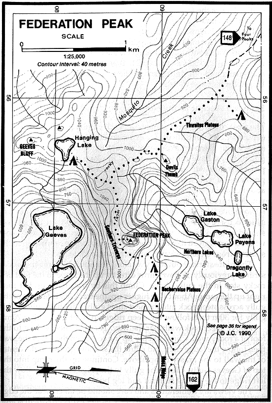
Map of the area around Federation Peak (from J.Chapman)
GPS
Upper Berchervais Plateau
Immediately above the upper Bechervaise Plateau camping area to the L is an imposing pillar of rock.
Peter Heddles, David Neilson, Feb 1968
Bechervaise Plateau Face
This steep face overlooks Bechervaise Plateau and forms the northern side of the summit block. As seen from below, the view is considerably foreshortened; however, the height, in excess of 120m, is soon appreciated when one is at grips with a climb on this excellent cliff. Five of the routes on this face start at a line of weakness toward the left hand edge of the face, below and slightly on the right of an obvious yellow diedre (Golden Diedre).
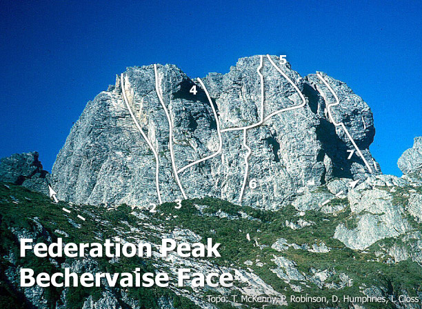
Bechervaise Face
The Climbing Gully
36m12when dry (Hard Difficult)Geelong College party, lead by John Bechervaise 1949
Davies and Wilbur
160m (approx)14To the R of the original Climbing Gully Route is the aptly named Jagged Wall, around to the L from the obvious corner of Golden Diedre. Start around the centre of this wall and take the easiest line of attack between the chimney on the L and the overhangs on the R.The belay on the first pitch is in a sentry box.Towards the top move R under a big bulge and continue to the top close to the Golden Diedre wall.
John Davies and Neil Davidson, 1972.
Rod Harris, Peter Heddles, Feb 1968
Rob Taylor, Reg Williams (alt), Chris Baxter, Jan 1965. Variations: Jim Newlands, Mike Stone, Jan 1966, John Moore, Reg Williams, Jan 1966
John Young, Joan King, Brian Wells, Burnie Rymer, Jan 1952
Faye Kerr, Bill Brewsher, Dec 1951
Anders Bown, Kate Snowball, Garn Cooper, 14 Mar 2009.
Two Pools
200m16Bryan Kennedy and Lyle Closs, 1971.
North Face
The "North" face of Federation Peak is the wall facing the prominent pinnacle at the top of the gully to the north of the summit block. Its right-hand edge is defined by a sharp arête that is visible as the right skyline when viewed from the Bechervaise camp. The North Face is separated from the Bechervaise Face by a large chimney system.
Richard Eccleston and Tim Chappell (various leads) 3 Jan 1997.
A serious undertaking, same access as the north face route and start. Traverse progressively rightwards for 55m (14) with some runouts to grassy ledge and belay. Traverse 10m right then 7m (16) on small gear up to belay just under the Arete flake system. Follow the steep flakes with expiring biceps and confidence up and right to gain the exposed arete (crux) 25m (21) belay with whatever you can find at the ledge. Up 30m (10) to start of the slab, then 70m (3) scramble to the summit.
Michael Lehmann, Harrie Van De Linde. 23/01/2022
North-West Face and Blade Ridge
The North-West Face and the Blade Ridge together form the most spectacular feature of the Federation Peak massif. Emerging from the clinging vegetation of the Northern Lakes valley, the Blade presents a slim, tapering, vertical face, above which a series of giant, razor-crested steps rise to meet the North-West Face at about 250m below the summit of the mountain. From here, the Face towers as a near vertical wall, its sweep broken first by the Bus Stop ledge and then by a huge overhanging roof 60m below the summit.
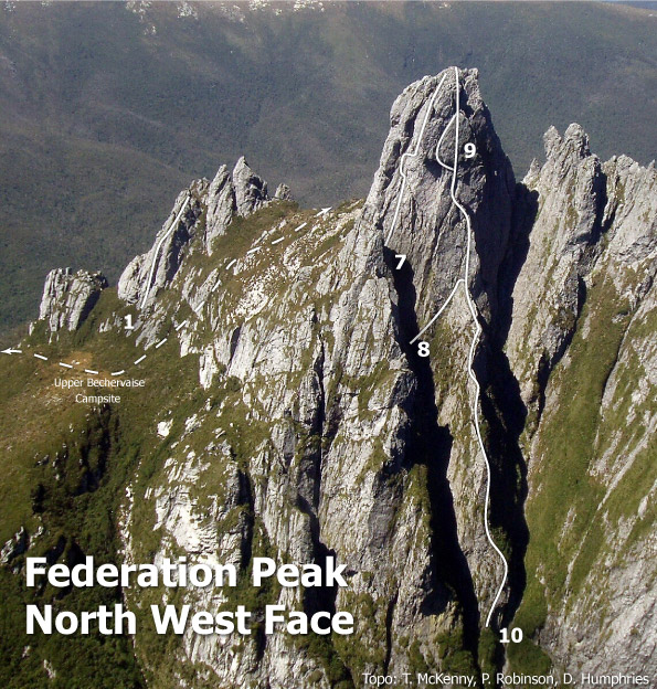
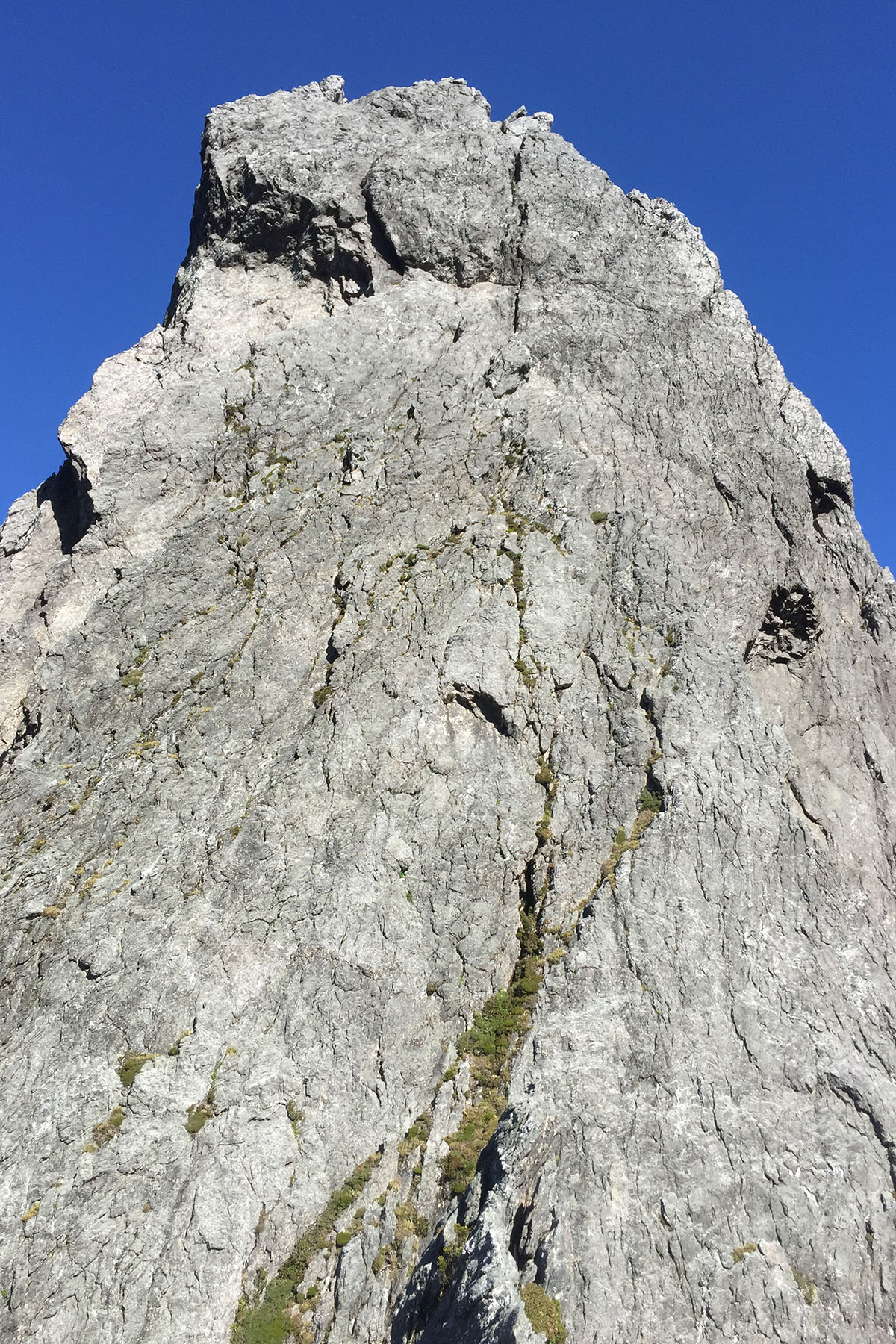
Bob Jones, Jack O'Halloran (alt), Geoff Shaw, and Rob Dunse 2 - 3 Jan 1961
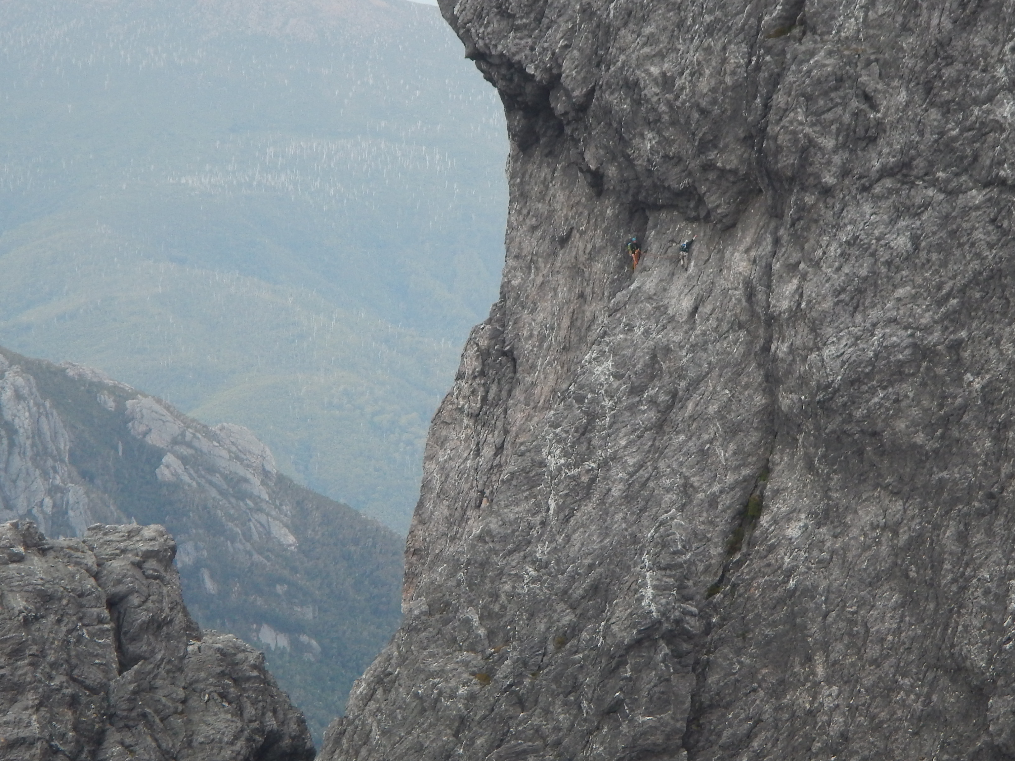
Reg Marron, John Croker, Keith Egerton, 1979
Peter Heddles, Rod Harris, David Neilson, Jack Woods (var), Feb 1968
Joe Goding (2,3,5,6) Simon Dadley-Moore (1,4), Jan 1996.
Karl and Mendelt's Route
150m+13Descend as for Joe and Simon's horticultural expedition and follow the crack/chimney on the RH side of Blade Ridge for about three pitches to the ledge on top of Blade Ridge.
Karl Prinz and Mendelt Tillema, 1973
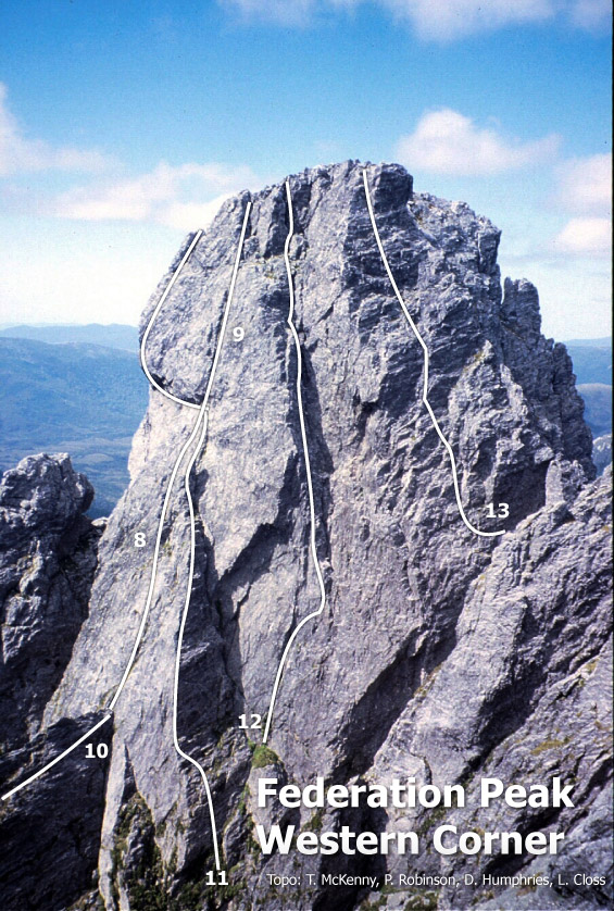
Western Corner
Proud arete west below summit, start RH side of arete traversing into the LH crack and up, traversing right in the last 5m. Highly technical climbing of increasing steepness with good pro on superb rock.
Michael Lehmann 22/01/2022

K. Prinz, L. Closs, Jan 1971
L. Closs, K. Prinz (alt) Jan 1971.
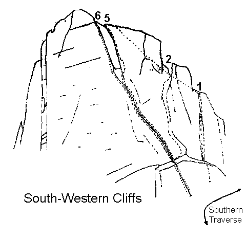
South Western Cliffs
These form the somewhat broken aspect which the Peak presents when viewed from the vicinity of Hanging Lake.
The Southern Traverse
1km, 1 to 2 hoursThis is the high level route from Bechervaise Plateau to Thwaites Plateau. It traverses across the steep southern face of Federation Peak. The route now has track marker but there is some dangerous and awkward scrambling with tremendous exposure: there have been at least two fatalities here and great care is required care to cross it safely. If you are carrying a pack allow up to double the times given above. The route is also used to gain access to the normal route to the summit.
Start on the Terrace, near the foot of the Climbing Gully, at the top of a deep cleft (Geeves Window) through which Lake Geeves is visible. Pass through the cleft and descend steeply until an easy traverse to the west is possible. Climb a narrow couloir, passing under an enormous chockstone, to reach the top of a broad buttress against the main summit block. Continue west, and descend from the buttress into the broad which runs down from the SW corner of the Peak. Ascend this couloir, and follow the ridge toward Thwaites Plateau and Hanging Lake.
Start: In the upper part of the broad couloir on the south side of the deep notch formed where the ridge from Thwaites Plateau joins the peak. Climb directly up, over rock of varying difficulty, and via a prominent chimney, to a point where descent into Geeves Gully is possible.
Bill Brewsher, Joan King, Dec 1951.
This is the cairned route to the summit used by bushwalkers. It follows roughly the same line as MUMC Route No. 2. Start about half way along the Southern Traverse at a large cairn on top of the 'broad buttress'. Follow cairns directly up the slope to the foot of a rocky step in the gully above. Climb this by traversing up left then right up the ramp. About 10m higher up, the track leads left out of the gully across steep rock into the next short gully. Climb steeply up this gully for 30m then follow the steep ridge up right for another 20m. Above sheer rock walls bar the way. The route heads right to the foot of a rocky wall. Climb steeply up the comer on the left of the wall then follow the ledge right and climb the shallow groove in the centre of the wall to the grassy ramp above. Continue up the ramp into the top of Geeves Gully. Climb the gully to the ridge crest and follow the left ridge to the roomy summit and log book.
Brian Wells, John Young, Dec 1951. Cairned in 1967 by the HWC.
Start as for the Normal Route. Climb up a long gully leading towards the summit, until the way is blocked by a large overhang. Bypass this on the right and climb directly to the summit.
Bill Brewsher, Bruce Graham (alt.) Jan 1952.
Start as for the Normal Route. Climb the arete to the left of the long gully of MUMC Route 5. On reaching the overharng ascend the chimney on its left and continue to the summit.
Faye Kerr, John Young (alt.) Jan 1952.